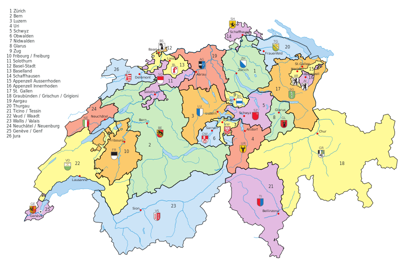
File:Kantone der Schweiz.svg

Size of this PNG preview of this SVG file: 800 × 560 pixels. Other resolutions: 320 × 224 pixels | 640 × 448 pixels | 1,024 × 717 pixels | 1,280 × 896 pixels | 2,560 × 1,792 pixels | 1,000 × 700 pixels.
Original file (SVG file, nominally 1,000 × 700 pixels, file size: 2.86 MB)
File history
Click on a date/time to view the file as it appeared at that time.
| Date/Time | Thumbnail | Dimensions | User | Comment | |
|---|---|---|---|---|---|
| current | 19:35, 26 July 2016 |  | 1,000 × 700 (2.86 MB) | Pit8404 | Kt. Zug die Fehlende Nummer 9 gesetzt, Appenzell und Waadt korrigiert, bei Graubünden die räto-romanische Bezeichnung hinzugefügt. |
| 03:44, 1 December 2009 |  | 1,000 × 700 (2.72 MB) | Inductiveload | missed a couple, try now. <mutter>stupid renderer can't understand manual kerning</mutter> | |
| 03:39, 1 December 2009 |  | 1,000 × 700 (2.72 MB) | Inductiveload | the problem is caused by manual kerning of the text. removed that, and it _should_ be OK. | |
| 03:27, 1 December 2009 |  | 1,000 × 700 (2.72 MB) | Inductiveload | hmm, that made it worse, try again | |
| 03:21, 1 December 2009 |  | 1,000 × 700 (2.72 MB) | Inductiveload | remove underlying borders, move water to a new layer and try to fix text | |
| 02:28, 1 December 2009 |  | 1,000 × 700 (2.76 MB) | Inductiveload | convert text to a font that renders better. resize image to a round 1000x700 | |
| 15:50, 9 March 2009 |  | 1,052 × 744 (2.85 MB) | Ofrick | Korrektur Name Kanton Aargau | |
| 13:34, 9 December 2008 |  | 1,052 × 744 (2.85 MB) | KarzA | {{Information |Description={{en|1=Vectormap of Switzerland with all canton, names and flags as separated layers}} {{de|1=Vektorkarte der Schweiz mit allen Kantonen, Namen und Flaggen als separate Ebene}} |Source=Eigenes Werk (own work) |Author=[[User:Karz |
File usage
The following 2 pages use this file:
Global file usage
The following other wikis use this file:
- Usage on ar.wikipedia.org
- Usage on ast.wikipedia.org
- Usage on ckb.wikipedia.org
- Usage on cy.wikipedia.org
- Usage on de.wikipedia.org
- Usage on en.wikipedia.org
- Usage on hr.wikipedia.org
- Usage on id.wikipedia.org
- Usage on ie.wikipedia.org
- Usage on ja.wikipedia.org
- Usage on rm.wikipedia.org
- Usage on sh.wikipedia.org
- Usage on sl.wikipedia.org
- Usage on tl.wikipedia.org


